BIM = Better Decisions, and This Landscape Architect Proves It
sponsored by Vectorworks

Today’s rising sustainability targets mean the need to forecast site performance has never been higher. Landscape Architects of Pacific Coast Land Design leverage BIM technology to analyze project sites and make more-informed design decisions, ultimately doing their part in sustainable site design.
The Site | Westview Village
Constructed in 1957, Ventura County’s Westview Village originally consisted of 180 housing units, making it the oldest and largest affordable housing complex in the area.
In an article for the Ventura County Star, the CEO of the Housing Authority of Buenaventura said that the affordable housing crisis in California spurned the complex’s revitalization efforts. The Housing Authority relied on RNT Architects, Mainstreet Architects and Planners, and Pacific Coast Land Design (PCLD) for planning and design, aiming for a 21st century build that can sustain long into the future.
The 20-acre master plan depicts 320 new housing units in place of the old 180 with a full 2 acres of open space used for community events, recreation, and a community-wide gardening program for onsite food production.

All images courtesy of Pacific Coast Land Design.
Making Water Management More Sustainable
The project aimed to exceed LEED Neighborhood Development benchmarks, so PCLD worked with Jensen Design Engineering to develop a stormwater management system that recycles much of the complex’s runoff. Drought-tolerant and low water-use plants decrease the need for irrigation water, which is largely obtained through recycled greywater, including laundry water, according to PCLD Principal Eric Berg.
Developing these sustainable water systems required heavy support from Vectorworks Landmark’s building information modeling (BIM) capabilities. During planning and design, PCLD linked data-rich worksheets to the site model for visualized insights. Their model contained vast amounts of live information needed to push towards more sustainable systems — at the start of the project, for example, PCLD worked with an arborist to get a detailed report on every one of the 209 onsite trees. They then linked this report with Vectorworks Landmark’s Existing Tree tool and used the information to develop a tree preservation plan.

All images courtesy of Pacific Coast Land Design.
In addition, PCLD were able to import the architect’s building models in the IFC file format, which allowed them to model the greywater capturing system within its greater context. This helped them to account for the various greywater sources and to include them in the calculations for overall site water use.

All images courtesy of Pacific Coast Land Design.
How BIM Technology Enables Informed Decisions
Through use of data visualization, which is the process of assigning visual treatments to geometry to represent associated worksheet data, Berg finds a flexible way to analyze the site.
“Data visualization is one of the most exciting capabilities in the software,” Berg said. He shared an example of assigning different numbers and colors to a site’s hydrozones so he could very quickly identify the various plant groupings. He also demonstrated using data visualization to indicate plant water usage to quickly see how water is being allocated across the site.

All images courtesy of Pacific Coast Land Design.
For an irrigation system, he assigned target pressure values and used data visualization to indicate whether the system would function as intended. With 60 PSI in the first image, the irrigation system starts to lose pressure, which is shown via shades of green.
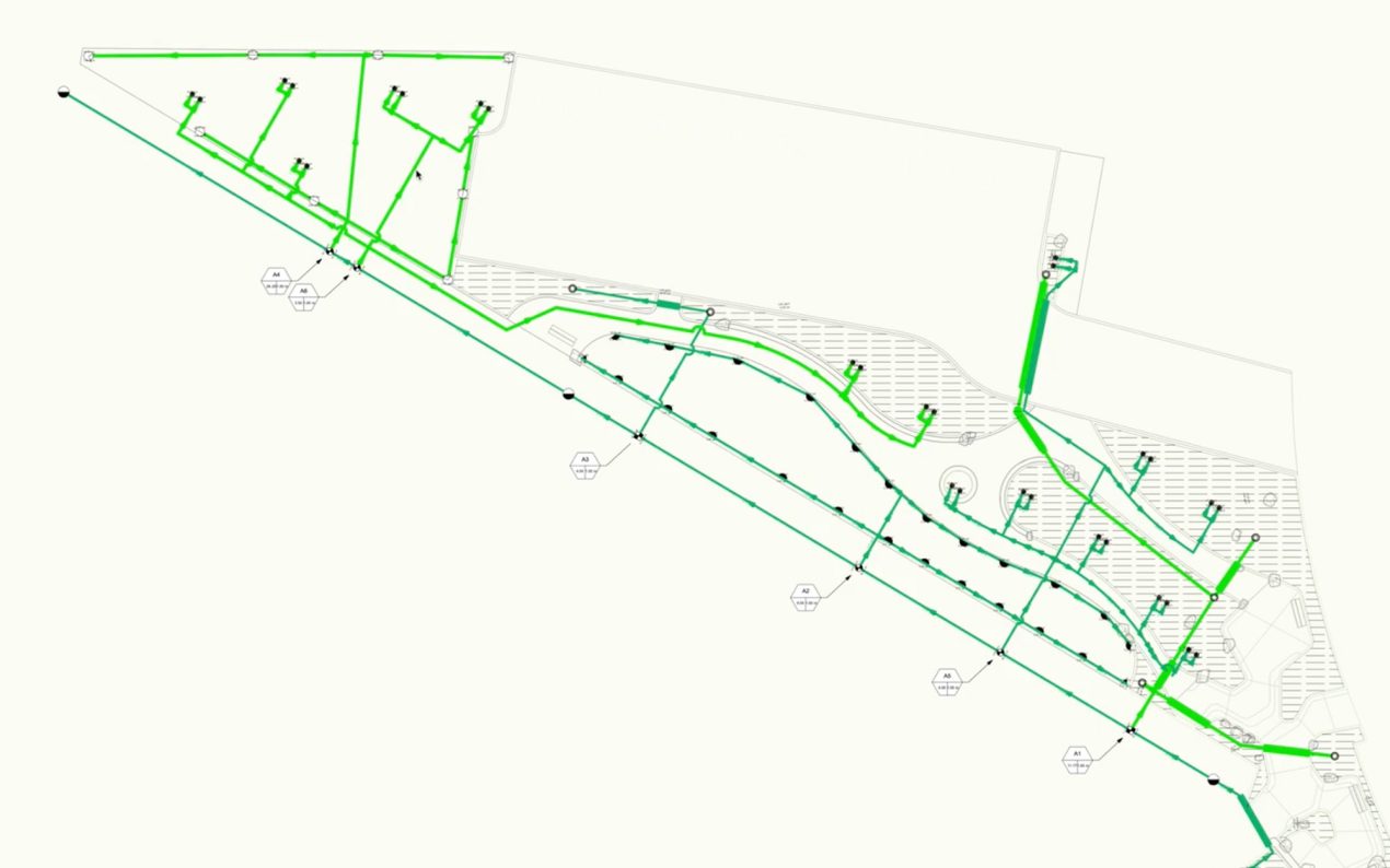
All images courtesy of Pacific Coast Land Design.
As he reduced the PSI to 40, the colors in his drawing changed, letting him know that 40 PSI was not sufficient pressure for the irrigation system.

All images courtesy of Pacific Coast Land Design.
In these instances, Berg was able to forecast performance long before on-site implementation, expelling any doubt that the project will meet its sustainability goals. Hear more from Eric Berg on how he uses Vectorworks throughout the project lifecycle.
All images courtesy of Pacific Coast Land Design.


, NY")


